
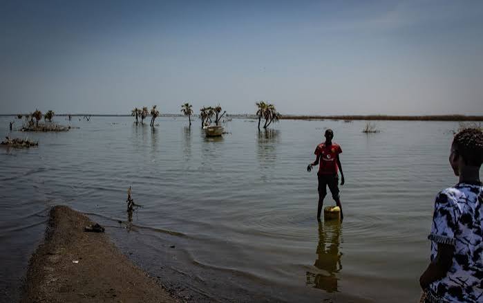
A natural cycle that sees lakes fluctuate, an increase in rainfall amounts that is being witnessed in the Eastern Africa region, coupled with degradation of the catchments is believed to be causing water levels in the rift valley lakes to rise.
The waters in the East African rift valley lakes are said to have started rising since 2010, and reached high levels around 2015 to 2016, and have sustained the high levels. This when checked against the El Nino events since 1997 when there was a strong El Nino event shows that around 2014 to 2016 was a prolonged El Nino with a multi-year cycle, that peaked in 2015 to 2016, bringing with it, heavy rainfall.

Hypotheses, studies have been done by scientists from the region, known as paleoclimatologists (scientist who study ancient climates and how weather patterns changed over the history of the Earth) and paleoecologists (scientists who study ancient organisms and their relationships with past environments across geological timescales).
“They have studied sediments from the bottoms of the lake, because the sediments record the history of the area, in terms of fossils, remains of plants and microscopic animals, used the chemistry of the sediments as well as the organic geochemistry of materials that have been left behind by living organisms,” says Professor of Environmental Geoscience at the University of Nairobi, Prof. Daniel Olago,” and adds, “They then date the sediments using carbon-14 dating and assign the ages to every different event.”
Through the studies, the researchers have been able to assign quantitative temperature and precipitation values which reflect what is happening in the catchments of the Rift Valley lakes. They have also looked at geomorphological evidences like raised beaches or wavecut shorelines, which help to show the extent of the lakes in the geological past.
According to Prof. Olago, what is seen in the sediments is that “there have been cycles of fluctuations of the lakes, some happening at inter-annual scales while others happen on decadal scales and others on centennial scales, and this has shown that, these lakes dried out in the past, and have also been seen at much higher levels, than what we have seen today.”
The Professor of Environmental Geoscience cites examples that 10,000 years ago, lake Naivasha and lake Elmentaita was one lake, and that13,000 years ago, Lake Victoria completely dried out, and only began its recent overflow about 8,000 years ago.
Using data, researchers have found that, the lakes’ water levels are rising and “they are rising across the Eastern Africa region including in Ethiopia, in Tanzania’s, Lake Manyara, Lake Natron, and in Uganda, as well as Lake Victoria itself, says Prof. Olago and adds, “We have seen these cycles occurring in these lakes over very small changes in precipitation,” he attributes the scenario to deforestation in the catchments, noting that increases in the amount of water that stays on the surface with most of it flowing directly into the lakes rather than seeping into soils, and into ground water storage systems could also be contributing to the rising lake levels.
“A combination of deforestation and heavy rainfall results into erosion, so the eroded sediments flow into the lakes which end up holding more sediments at the bottom of the lake,” he says and adds, “This phenomenon made me to think that the reason why these lakes are rising is because of an atmospheric phenomenon which is regional.”
He further notes that paleoclimatic studies have shown that very small changes in the amount of rainfall can induce very large hydrological responses from lakes, because of the increase in inflows into the lakes, “10,000 years ago was a very wet period as shown in the studies by paleoclimatologists and paleoecologists, Lake Turkana for example was 90 meters above its current level, Lakes Elmeintaita and Lake Naivasha had merged and were covering much larger areas than they are today, yet the amount of rainfall change was only 10 to 30 per cent the amount of rainfall that we receive today,” he notes.
Prof. Olago is certain that, the rising lake levels is more of a climate phenomenon, “notwithstanding the effects of degradation and erosion making it worse, at local scale because the degradation of the catchments are different across the entire region” he avers, and adds, “Degradation has worse effects than just rainfall changes, because it brings in pollutants, brings in sediments, changes the dynamics of the lakes, it changes the food chain it has many multiplier effects.”
For Lake Baringo and Lake Bogoria, the catchments are severely degraded due to deforestation where the area residents use biomass as an energy source, thus using charcoal and firewood, poor farming practices on steep slopes, and intense soil erosion due to unsustainable pastoralism that led to overgrazing, leaving the soil bare. This, together with accelerated surface runoff, results in massive sedimentation in the lakes. “From colonial government reports of the 1930s and 1940s soil erosion was already a problem, primarily because of large herds of livestock and increasing use of firewood as an energy source,” says Prof. Olago.
He warns that the lakes’ chemistry is going to change when they merge, because Lake Bogoria is an alkaline lake while Baringo is a fresh water lake. “We still have a meter before the overflow begins, this is where now, humans can come in with their technology and skills, if it was a fresh water lake draining into a saline, it wouldn’t worry, but it is the reverse, the saline is draining into the fresh water lake.”
The Professor of Environmental Geoscience says the solution to the environmental and ecological catastrophe that faces the two lakes, Lake Baringo and Lake Bogoria is int nature-based solutions, “regenerations of the catchments would help as more rainfall water would seep into the ground and form ground water instead of the surface water now draining into the lakes.”
He further notes that for any infrastructural development near lakes, “At more local scales you want to begin to think in a more systematic way in terms of how you plan your infrastructure one of the things that we do know is that we have a reconstruction of the lake levels from the past, so we can tell you where we expect them to be at some point in the future,” and adds, “follow the science, because the models we are using are telling us what to expect in the future.”