
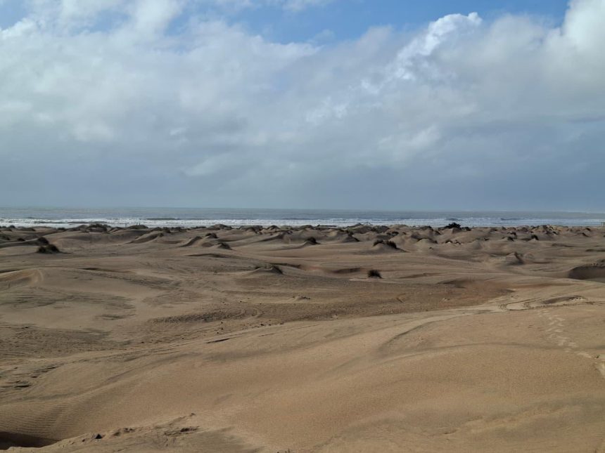
The sun sits high as an ocean breeze crosses the shore. Fine sand drifts into my sandals, and each time I take a step, I can feel grains of sand moving up the sandals reaching my toes as if saying, “I am coming to you.” Each step that I take just makes my feet grow heavier and each time I try to shake the sand off, even more finds its way back in.
As I go further into this small town along the Kenyan Coast, mounds of golden sand ripple and reshape with each gust of wind. The landscape of this town mimics desert life; think the Sahara or the Kalahari. In fact, it has been nicknamed Dubai Ndogo (little Dubai).

Welcome to Mambrui town in Kilifi County. The breathtaking coastal sand dunes extending between Malindi and Mambrui towns, both in Kilifi County, span approximately seven hundred hectares over a 10-kilometer stretch. These dunes form from sediments that reach the Kenyan Coast through the Sabaki River which starts its journey inland from Ngong Hills. The river joins other tributaries along the way from Athi River, and then Galana as it pierces through the Tsavo to pour in the ocean as Athi-Galana-Sabaki river. Ocean waves redistribute the sand along the shoreline, while wind carries it further inland, a natural process that enables formation of more and more sand dunes.
But wait, what exactly are these sand dunes?
Sand dunes explained
“Sand dunes are wind-derived, formed when coastal winds carry sediment inland from bare shores,” explains Amon Kimeli, a geologist who has worked at the Kenya Marine and Fisheries Research Institute (KMFRI) for more than 15 years.
“They begin as small mounds and build up over time. The newer formations sit close to the shore, while earlier and older ones which date back thousands of years are far removed from the shore.”
“Welcome to Mambrui!” calls Charles Nathaniel, a senior village elder, his voice carrying over the wind.
“The tourist season is just picking up, and we’re fully booked through January,” he speaks of his home with pride.
“Mambrui is a culturally rich coastal settlement with a history spanning nearly 800 years. Today, it is home to close to 2,500 households and is a major tourist attraction where guests come to enjoy a desert-like experience with nothing more than their Kenyan identity card, soak in the atmosphere, and learn about our culture.”
“Habibi! Welcome to Dubai Ndogo!” an energetic voice interjects. Locals use the name “Little Dubai” because the dunes Gulf desert landscape. A young man greets the elder respectfully, and then offers his services as a guide. His name is Said Salim. Three years ago, he joined Mambrui-Mjanaheri Beach Tourism Community-Based Organisation that brings together more than 100 local youths in dune tourism.
“These dunes are everything to us,” Said say.
“They are a major source of employment for young people here, which haseduced local crime and drug abuse. Through these dunes, I can provide for my child,” he adds softly, turning toward his quad bike.
Earnings follow the seasons. “On an average, you can make between Ksh 1,500 and Ksh 2,000, in a day, which is enough to support a family.” The “Dubai Ndogo” branding is more than a marketing hook. Locals have reimagined a landscape once seen as a threat as a source of pride and income, repositioning Mambrui as a site of wonder rather than a disaster zone.
Conserving the sand dunes
The dunes need constant tending. Every weekend, groups of 15 youths gather to clean the area and care for the vegetation that anchors the sand. “We care for a variety of plants, including coconut and mango trees,” Said explains.
“Beyond adding beauty, their root systems are essential for holding the moving sand in place,” he adds.
Nathaniel, the village elder, says long-term protection needs more than weekend cleanups. The community runs several conservation projects, including mangrove restoration.
“We recently researched plant species like Casuarina, which act as effective windbreakers to prevent sand from engulfing our village,” he says.
“Without vegetation, the sheer force of the wind would drive the sand right into our homes and cover our infrastructure.”
Nathaniel points toward the horizon to show what inaction costs. “Over on the Mjanaheri side, an investor’s entire property was completely submerged by the shifting sand.”
John Yeri who has lived in Mjanaheri Village for 45 years and walked the dunes with me, names the causes: “Human activities like shoreline deforestation and unregulated sand harvesting have severely altered the shifting patterns and formation of Mambrui’s dunes,” he says.Businesses along the seashore have been forced to close, investments completely buried by sand dunes. Yeri says that “Even public infrastructure, including mosques and local dispensaries, have been entirely swallowed by the shifting sand over the years. You wouldn’t even know they were once there.”
One of the reasons for this shift is economical. Beyond the movement of the sand dunes further inland towards settlements lies the rich heritage of this local coastal community, a heritage that the residents are eager to share with the rest of the world through ecotourism activities. Ecotourism allows them to welcome visitors to the area while supporting conservation efforts and creating livelihoods from the dunes. However, activities such as quad biking can disturb the dune sediments, making the sand easier for the wind to lift and potentially accelerating dune movement.
Forces shaping the sand dunes
The Kenya Meteorological Department’s State of the Climate in Kenya Report 2025 found that June-August brought the strongest and most widespread winds, with enhanced speeds across the open ocean and along the coastline. Joel Kingi Dzanga, the Chairperson of Kilifi Climate Change Committee and Secretary General of Kilifi County Disaster Committee, says coastal winds contribute to the movement of sand and the formation of dunes.
“Winds emanate from the ocean, and during high tides, they move at high speeds, affecting marine life and human economic activities at the beach,” he says.
Locals avoid swimming in the adjacent ocean. Dzanga says the wind there is very strong and the tides change minute by minute, so it is impossible to predict when conditions will calm.
Wind is only part of the story. Kimeli says another challenge is the pumping of groundwater from beneath the dunes, which he believes affects their stability. He explains that as sand builds up in layers, water collects and is stored within it. The sand helps filter the water, allowing some freshwater to collect beneath the dunes.
“Because the sand dunes act as natural sieves, filtering out salt and other impurities, the water trapped in the dunes is often fresher than water obtained from a borehole, and this is why communities drill the dunes right next to the ocean in the coastal strip,” he says.
Scientists have measured dune migration in other parts of the world, offering a way to understand how quickly moving sand can reshape a landscape.
In Mauritania, a peer-reviewed study published in the Journal of Geophysical Research: Earth Surface in 2007 tracked 50 crescent-shaped desert dunes over one year. Researchers found that the dunes moved between 10 and 25 metres during that period, averaging about 20 metres annually.
In Mambrui, geologist Amon Kimeli’s field observations suggest that the landscape has changed over recent decades. The submerged hotel and businesses affected by shifting sand illustrate the consequences for local livelihoods. But to determine whether the dunes are moving faster, and at what rate, their positions would need to be compared using historical imagery and field measurements.
The encroaching sand
Eight minutes by road from the main dunes is the Mjanaheri entrance. It is just as busy, with rows of quad bikes and young guides waiting for visitors. James Juma, 21, steps forward to tell his story.
“These dunes gave me a lifeline,” he says.
“After completing Form 4, I went to driving school, but afterward, I found myself sitting idle. To avoid falling into destructive habits, I registered with the Mambrui-Mjanaheri Beach Tourism Community-Based Organisation as a tour guide. I’ve been doing this for two years, and at least I can’t miss Ksh 500 in a day, while on good days I earn up to Ksh 5,000.”
He leads the way across the sand and stops beside a partly visible structure, the remains of the submerged hotel.
“This hotel was first threatened by shifting sand in the early 2000s, and by the late 2000s, it was completely engulfed,” James says.
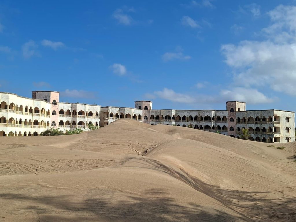
“That section right there was the parking lot. There are actually vehicles buried beneath us. In the middle was a swimming pool, now completely hidden. As a community, we tried putting up physical fences to block the sand, but the dunes just swallowed the fences whole every time.”
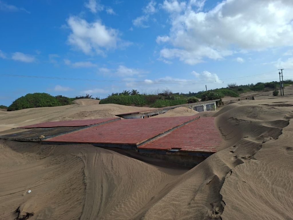
As the shifting sand swallowed their land, residents began turning to ecotourism to earn a living, organising community-based groups to support these efforts. Alongside these new livelihoods, they embraced a different approach to controlling the sand: planting and protecting vegetation rather than relying on built structures alone, what is known as green investments or nature-based solutions.
“Over there, we’ve planted rows of Casuarina trees to trap the sand,” James says, pointing toward a dark line of trees.
“With these trees, the sand slows down and cannot move past this place to where our buildings are.”
Research by the Kenya Forestry Research Institute explains why Casuarina suits the coastal region. Casuarina is one of the few tall trees that can withstand strong coastal winds and heavy salt spray. Planted as a shelterbelt just behind the high-tide line, its flexible, needle-like branchlets filter ocean winds, curbing inland erosion and shielding the settlements and fields behind the beach. Residents report noticeably less encroachment since the trees matured, which takes roughly three years in freshwater conditions and longer in saline ones.
Planting of mangrove trees
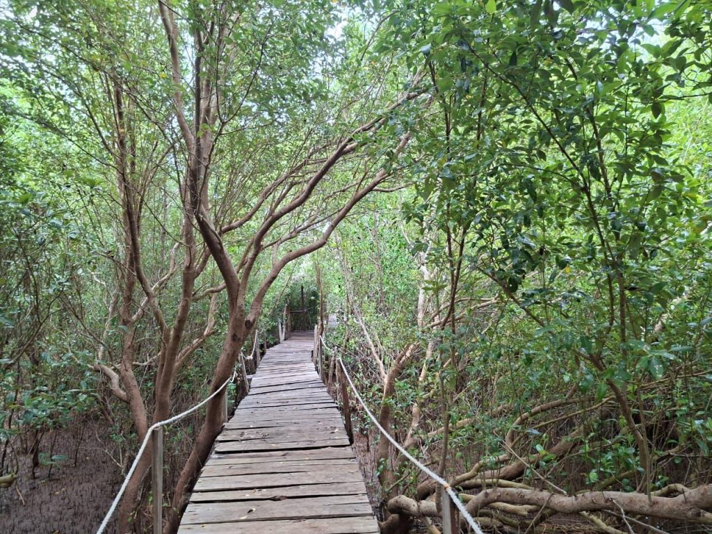
About 15 kilometres north of the main dunes, along the Sabaki River, several ommunity-based organisations work side by side to protect the wider coastal ecosystem. Kimeli is emphatic about why this matters.
“For the Sabaki River, the mangroves stabilize the sediments and hold the soil together,” he says.
“Conservation is helpful to the sand dunes habitat because they form a symbiotic relationship; the sediments that form the sand dunes are held together by the mangroves.”
The estuary, or the mouth of the Sabaki river is under heavy pressure.
The Sabaki River Estuary Short Report, prepared for a Marine Spatial Planning workshop and published in 2021, says the sediment load of the Athi-Sabaki river has risen from about 50,000 tons a year in the 1950s to 5 to 13 million tons a year, largely because of poor land use upstream.
At the site I meet Benson Kadenge, a member of the Sabaki River Conservation and Development Organisation (SARICODO), which he says includes 65 youth and 30 women. The group balances conservation and tourism through guided tours, bird watching, hippo viewing and dune hiking.
Under a benefit-sharing rule, 10 percent of ecotourism revenue goes to conservation work such as buying mangrove seedlings, and another 5 percent to mangrove protection.
“The mangroves here act as a barrier,” Kadenge explains.
“During flooding, there is normally a lot of silt coming downstream, but the mangroves are able to traps the silt and reduces erosion, leading to an improvement.”
Mangroves take about 10 to 15 years to mature. Women carry much of the work. Lina Dama heads the Patanani Women’s Group, a SARICODO branch at the Sabaki Boardwalk, whose members plant and tend mangroves in local nurseries.
“Those mangroves that we take care of, we keep them in the nursery. Once they are there, when we get donors and sell to them, we make money,” she says.
“The profits enable us to pay for our children’s school fees and other development projects. For example, I did not have a house, but this project has given me one, and I’m now able to keep livestock goats and chicken as well.”
According to the Sabaki Estuary Management Plan 2023–2028, the estuary had extensive mangrove forests in the 1950s, but by 2000, only about 14.7 hectares remained. By 2022, mangrove cover had recovered to approximately 71.9 hectares.
Joseph Mangi, SARICODO’s chairman, describes why dunes are important. The dunes function as water tank reservoirs during rainy seasons as they absorb rainwater which comes in handy during hot seasons; the residents only have to dig shallow wells, and voila! they get freshwater for domestic use. Similarly, adds Mangi, “water from the dunes flows underneath and percolates to replenish the mangrove forest. You know mangrove forests survive when they have a mix of fresh water from the river and salty water.”
Mangi explains how flooding carries silt downstream and how the resulting sand movement affects the coastal ecosystem.
“The river, when it floods, receives a lot of silt from upstream, which deposits a lot of sand in the ocean. Due to the tide cycle, the sand is blown off, so there is a lot of sand shifting in the sand dunes. This has a detrimental effect: it fills the mudflats, which are feeding grounds for the birds. Even in some areas we have already restored, the shifting sand kills all the mangroves that have been planted,” he says.
The loss is already visible in the species list.
“Right now, we are losing some of the mangrove species like Heritiera littoralis,” Mangi says with concern.
“Initially we had six species, but the one that used to grow near the river bank went extinct because of siltation.”
Mangi says that to address the problem of excessive sediments reaching the Kenyan Coast, efforts must be made along the entire Athi River Basin. He points out that construction of dykes and dams upstream where sediment can settle could regulate the amount of sand reaching the Coast while also ensuring the communities along the basin have access to clean water.
The writer is a Radio Producer/Presenter at the Kenya Broadcasting Corporation (KBC). This story was supported by Informed Earth.