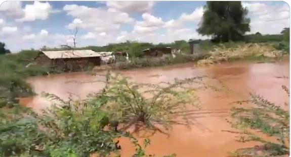
The Government has identified 59 flood-prone areas across Tana River County as rising water levels from the Seven Forks Dam continue to heighten risk in low-lying settlements.
According to the Ministry of Interior, Tana Delta is the worst-hit sub-county, accounting for 32 of the identified high-risk zones.

Ten other areas are in Tana River Sub-County, eight in Bangale Sub-County, six in Tarasaa Sub-County and three in Tana North Sub-County.
The mapping exercise follows repeated weather alerts warning of increased flooding risk due to rising river discharge linked to the Seven Forks hydroelectric system upstream.
In Tana Delta, the affected areas include Feji, Kiembe, Halubha, Sera, Bwoka, Tsanankuu, Godhey, Dobaley, Abaganda, Salama, Ndera, Wema, Galili, Chira, Bilisa, Shirikisho, Kipini Division, Miliki, Majaliwa, Onido, Ndiponi, Kau, Kilelengwani, Kalota, Pungaupepo, Kidhanga, Diribu, Magogoni B, Kajisten, Ndimimbii, Ribe A and Ozi Mtangani.
In Tana River Sub-County, at-risk locations include Masabubu, Rhoka, Kinakomba-Boji, Emmaus, Watta Hamesa, Vukoni, Mkomani, Bondeni, Laza-Makaburini, Makere, Bowa, Mbalambala, Mororo, Saka, Madogo, Tula, Ziwani and Bulto Banta.
In Bangale Sub-County, the identified areas are Bura, Chewele and Hirimani, while Tarasaa Sub-County includes Kipao, Ongonyo, Odole, Konemansa, Kigomo and Manono.
Bura, Chewele and Hirimani locations in Tana North Sub-County have also been also flagged.
Residents in all identified areas have been urged to remain on high alert and relocate to higher ground when directed by security agencies as water levels continue to fluctuate.
“The Government, in collaboration with multi-agency response teams, continues to monitor the situation and coordinate response efforts across affected regions,” said the interior ministry.
Nationwide flood impact
Nationwide, 18 deaths have been confirmed as of May 2, 2026, most of them resulting from drowning incidents amid ongoing flooding in several parts of the country.
The Eastern region has recorded the highest toll at nine fatalities, followed by Central (three), Coast (two), Nairobi (two) and Rift Valley (two).
In Nairobi, floods have affected an estimated 6,600 people, displacing families and damaging roads, schools and residential estates across multiple sub-counties.
In Central Kenya, counties including Kirinyaga and Kiambu have reported widespread destruction, with bridges and road networks cut off while in Mwea West alone about 3,000 residents have been displaced.
In the Eastern region, Makueni County has reported the highest number of fatalities, with flash floods and mudslides also destroying homes and damaging critical infrastructure, including roads and power lines.